Advanced radar water level and current station
Sticking to the belief of “Creating products and solutions of top of the range and creating friends with men and women from all over the world”, we generally put the curiosity of consumers in the first place for Advanced radar water level and current station, should you may have any query or wish to place an initial purchase be sure to never hesitate to contact us.
Sticking to the belief of “Creating products and solutions of top of the range and creating friends with men and women from all over the world”, we generally put the curiosity of consumers in the first place for , They’re durable modeling and promoting well all over the world. Under no circumstances disappearing key functions in a brief time, it’s a must for yourself personally of fantastic quality. Guided by the principle of Prudence, Efficiency, Union and Innovation. the business make an awesome efforts to expand its international trade, raise its enterprise. rofit and improve its export scale. We have been confident that we will have a vibrant prospect and to be distributed all over the world in the years to come.
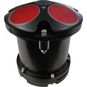
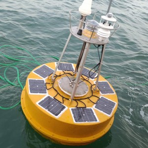
The Radar Water Level & Velocity Station relies on radar non-contact measurement technology to collect key hydrological data such as water level, surface velocity and flow in rivers, channels and other water bodies with high precision, all-weather and automated methods. It effectively overcomes the shortcomings of traditional contact sensors that are easily affected by siltation, freezing, impact of floating objects and biological attachment, and ensures long-term reliability of data.
This station integrates satellite precise positioning, 4G/5G full network access remote communication and efficient solar power supply system, supporting long-term unattended operation in extreme environments such as outdoor without mains power and network coverage, greatly reducing operation and maintenance costs. The collected data is transmitted to the monitoring center or cloud platform in real time. It provides a scientific basis for flood prevention and disaster reduction, water resources management and ecological protection, and significantly improves the efficiency of emergency response and safety of water conservancy facilities.
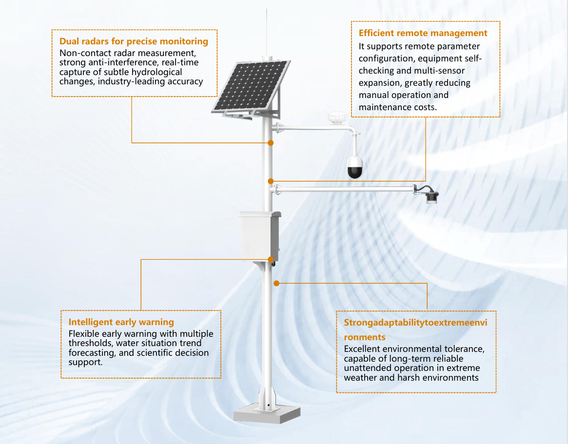
Product composition:
The product mainly consists of the following core modules:
① Radar current meter:
Realize non-contact and accurate measurement of water flow rate
② Radar water level gauge:
Realize accurate water level measurement, flood warning, flow calculation and water level trend analysis
③HD Camera:
Real-time image and video acquisition provides intuitive visual basis for water situation analysis, early warning information verification and on-site management
④Satellite positioning module:
Provide precise positioning, time calibration, equipment tracking and emergency dispatch support
⑤Intelligent collection terminal:
Responsible for data aggregation, equipment control, communication relay and remote maintenance, etc.
⑥Solar power supply system:
Provide stable, sustainable, off-grid energy security for the entire equipment

Specifications:
| Radar flow rate monitor |
Measuring range | 0.06~20m/s |
| Measurement accuracy | ±0.01m/s; ±1%FS | |
| Resolution | 0.001m/s | |
| Beam Angle | 12° | |
| Radar water level monitor |
Measuring range | 0.1 m ~65m |
| Measurement accuracy | ±1mm | |
| Beam Angle | 6° | |
| Image and video acquisition | Resolution | 2 million pixels |
| Image transmission | Support high-definition image transmission | |
| Night Vision | Yes | |
| Local Storage | Support TF card for local video recording | |
| Remote Access | Support remote viewing (real-time video stream and/or video files) | |
| Working Mode | Support 24-hour uninterrupted work | |
| Communication and positioning | Communication | 4G/5G full network, support GSM |
| Data upload interval | Configurable acquisition frequency | |
| Positioning method | Satellite Positioning | |
| Positioning accuracy | Horizontal ≤2.5m, height ≤5m | |
| Power and battery life | Photovoltaic panel power | 45W, select according to the device power consumption |
| Battery capacity | 20Ah (12V/24V) is selected according to the local sunshine conditions. | |
| Intelligent collection terminal | Interface | 5, can be increased according to the access device |
| Storage | Built-in flash memory, support TF card expansion | |
| Power supply | DC 12V/24V, wide voltage input |
Environmental adaptability:
Working temperature: -40℃~+80℃
Protection level: IP67
The radar water level & current monitoring station relies on radar non-contact measurement
technology to collect key hydrological data such as water level, surface velocity and velocity in rivers,
channels and other water bodies with high precision, all-weather and automated methods. It effectively
overcomes the shortcomings of traditional contact sensors that are easily affected by siltation, freezing,
impact of floating objects and biological attachment, and ensures long-term reliability of data.
The station integrates satellite precise positioning, 4G/5G full network access remote communication
and efficient solar power supply system, supporting long-term unattended operation in extreme
environments such as outdoor without mains power and network coverage, greatly reducing operation
and maintenance costs. The collected data is transmitted to the monitoring center or cloud platform in
real time. It provides a scientific basis for flood prevention and disaster reduction, water resources
management and ecological protection, and significantly improves the efficiency of emergency response
and safety of water conservancy facilities.We have been confident that we will have a vibrant prospect and to be distributed all over the world in the years to come.