Automatic Tide Gauge Station – High-Precision Tidal Level Monitoring System for Coastal and Hydrological Applications

Automatic Tide Gauge Station – High-Precision Tidal Level Monitoring System for Coastal and Hydrological Applications,
Automatic Tide Gauge, Automatic Tide Gauge Station, Automatic Tide Monitoring, Coastal Tide Monitoring, Coastal Water Level Monitoring, Hydrological Water Level Monitoring, Marine Tide Gauge, Real-Time Tide Monitoring, Tidal Level Monitoring System, Tidal Water Level Sensor, tide gauge station, Tide Level Measurement, Water Level Monitoring System,
1. Product Advantages
-
High Accuracy of Water Level Measurement: Precision pressure sensing delivers reliable water level data.
-
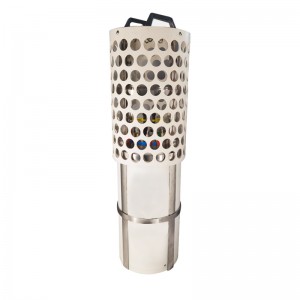
Temperature & Pressure Dual Sensors: Integrated high-precision pressure and temperature sensors in a single compact probe.
-
Real-Time Data Transmission & Cloud Management: Powered by 4G cellular telemetry and integrated with the MEINS Marine Equipment Intelligent Networking System.
-
Clean Energy & Autonomous Power Supply: Optimized for low power consumption with solar power supply supporting up to 30 consecutive cloudy days of continuous operation.
2. Manufacturing Process
-
Control Box Fabrication: Precision enclosure manufacturing using SECC Galvanized Sheet steel for rugged field durability.
-
Sensor Housing Machining: High-grade Polyoxymethylene (POM) housing fabrication for corrosion resistance in marine environments.
-
Electronics & Module Integration: Assembly of the Data Acquisition Module for real-time signal processing and 4G cellular transmission modules.
-
Power System Calibration: Wiring and testing of the 18V 50W solar panel and 12V 55Ah maintenance-free battery circuit.
3. Quality Control
-
Sensor Accuracy Calibration: Strict validation of pressure accuracy (±0.1% FS) and temperature accuracy (±0.005°C).
-
Telemetry & Network Testing: Comprehensive signal transmission verification using 4G Full Netcom and SMA antenna connections.
-
Power Endurance Check: Extended power-drain testing to guarantee autonomous operation for up to 30 consecutive cloudy days.
-
Data Retrieval & Back-Fill Audit: Verification of 32G local SD card storage, historical data view functionality, and missing data replacement protocols.
4. Product Parameters
Technical Specifications
| Category | Parameter Item | Values / Specifications |
| General Specifications | Box Size | 400 x 500 x 300 mm (Customizable) |
| Box Weight | Approx. 29 kg (Including battery) | |
| Case Material | SECC Galvanized Sheet | |
| Sensor Size | φ36 mm x 323 mm | |
| Sensor Weight | 128 g | |
| Sensor Housings | Polyoxymethylene (POM) | |
| Cable Length | Customized on Demand | |
| Operating Parameters | Sampling Period | 1 min ~ 24 hour (Customizable) |
| Cloud Platform | MEINS Marine Equipment Intelligent Networking System | |
| Data Features | Historical Data View & Replacement of Missing Data Supported | |
| Sensor Parameters | Pressure Range | 20 / 50 / 100 m Available |
| Pressure Accuracy & Resolution | Accuracy: ±0.1% FS | Resolution: 0.01% FS | |
| Temperature Range | -5 ~ 35°C | |
| Temperature Accuracy & Resolution | Accuracy: ±0.005°C | Resolution: 0.001°C | |
| Transmission & Storage | Communication Method | 4G Full Netcom |
| Operating Mode | Network Passthrough, Protocol Passthrough, HTTPD Mode | |
| Antenna & Local Storage | SMA Antenna | 32G SD Card | |
| Power & Range | Power Supply Method | Solar-Powered or Utility-Powered |
| Solar Panel | 18 V, 50 W | |
| Battery Parameters | 12 V, 55 Ah Maintenance Free Battery | |
| Endurance | Continuous operation under good light; Up to 30 consecutive cloudy days |
Optional Accessories
| Component | Description / Specifications |
| Mounting Bar | Customized according to site requirements |
| Weather Stations | Wind Speed, Wind Direction, Temperature, Relative Humidity, Air Pressure |
5. Product Models
| System Module | Component Description |
| Tide Sensor | Integrated high-precision pressure and temperature sensors with POM housing. |
| Data Acquisition Module | Real-time signal processing unit with 32G local SD card storage. |
| Communication Module | 4G cellular telemetry unit supporting network passthrough, protocol passthrough, and HTTPD modes. |
| Power Supply System | Solar panel (18 V, 50 W) and 12 V, 55 Ah battery power unit. |
6. Packaging & Transportation
-
Enclosure & Electronics Protection: Control box (400 x 500 x 300 mm, approx. 29 kg) packaged in custom foam-lined crates.
-
Sensor & Cable Transit: Sensor probe (128 g) and customized cables packed in protective non-corrosive sleeves.
-
Battery Transport Safety: Fully compliant packaging for the 12 V 55 Ah maintenance-free battery during ground or ocean transit.
7. Product Purpose
-
To provide automatic, long-term, and unattended continuous telemetry monitoring of water level and water temperature.
-
To deliver real-time hydrological observation data for cloud platforms, environmental monitoring centers, and water resource management systems.
8. Product Applications
-
Coastal tide observation stations and port hydrology networks
-
Inland river water level and temperature monitoring
-
Water resource management and flood early warning facilities
-
Environmental monitoring and marine research projects
“Data is for reference only; actual conditions shall prevail.”
The Frankstar Automatic Tide Gauge Station is a high-precision tidal level monitoring system designed for continuous and reliable water level measurement in marine and hydrological environments. The system automatically measures and records tidal variations, providing accurate data for long-term coastal and water level monitoring.
Designed for demanding outdoor and marine environments, the Automatic Tide Gauge Station supports continuous monitoring and reliable data acquisition. It can be deployed at coastal areas, ports, harbors, estuaries, rivers, and other locations where accurate tidal and water level information is required.
By providing real-time and historical tidal level data, the system supports oceanographic research, coastal engineering, port management, hydrological monitoring, and early warning of coastal hazards.
Key Features
High-Precision Tide Measurement – Accurately measures tidal level variations for reliable hydrological analysis.
Automatic Water Level Monitoring – Enables continuous and automated tidal level observation without frequent manual measurement.
Real-Time Data Acquisition – Supports efficient collection and transmission of tidal and water level data.
Long-Term Monitoring – Designed for continuous operation in coastal and hydrological environments.
Reliable Outdoor Deployment – Suitable for demanding marine and outdoor monitoring conditions.
Wide Range of Applications – Applicable to coastal monitoring, ports, harbors, estuaries, rivers, marine research, and engineering projects.
Applications
Coastal Tide Monitoring
Tidal Level Measurement
Hydrological Monitoring
Port and Harbor Monitoring
Estuary Monitoring
Marine Environmental Monitoring
Coastal Engineering
Oceanographic Research
Water Level Monitoring
Coastal Disaster Early Warning