Mooring Wave Data Buoy for Ocean Wave Monitoring and Marine Observation

Mooring Wave Data Buoy for Ocean Wave Monitoring and Marine Observation,
,
1. Product Advantages
-
High-Capacity & Modular Expandability: Supports adding extra sensors for profiling data monitoring (temperature, salinity, underwater acoustics, etc.) tailored to custom research requirements.
-
Long Operational Lifespan: High-capacity 340 Ah Lithium Battery Pack ensures reliable continuous operation for up to 12 months in field conditions.
-
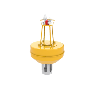
Robust PE Buoy Structure: Heavy-duty Polyethylene hull (68 kg, Φ936 mm) providing enhanced stability and wave-riding capabilities in harsh offshore environments.
-
Versatile Dual-Deployment Modes: Operates seamlessly in both drifting and moored configurations for comprehensive short-term or multi-year oceanographic monitoring.
-
Multi-Channel Real-Time Telemetry: Combined short-range (GSM/GPRS/4G, UHF/VHF) and long-range (Satellite) communication options for uninterrupted real-time data delivery.
-
Massive Data Storage: Equipped with 32G high-capacity internal memory for complete onboard data redundancy.
2. Production Process
-
Precision Hull Molding: Heavy-duty Polyethylene (PE) rotational molding to fabricate a seamless, impact-resistant, UV-stabilized 936 mm hull body.
-
Internal Modular Frame Assembly: Reinforced internal chassis installation to securely house the 340 Ah battery system, core controllers, and expansion sensor interfaces.
-
Multi-Sensor Assembly & Wiring: Precision integration of wave sensors and optional profiling sensors with IP68 marine-grade underwater connectors.
-
Power Management Configuration: High-energy 340 Ah Lithium Battery Pack integration featuring smart battery balancing and protection circuitry.
-
Hermetic Sealing & Encapsulation: Dual O-ring sealing and marine-grade potting application to guarantee absolute waterproof reliability under deep wave impacts.
3. Quality Inspection
-
Pressure & Ingress Testing: 100% full-immersion hydrostatic pressure and leak checks to guarantee seal integrity in open ocean conditions.
-
Sensor Calibration & Testing: Rigorous calibration of wave parameter algorithms (height, period, direction, spectrum) against certified laboratory standards.
-
Multi-Channel Telemetry Testing: Real-time transmission verification across Satellite, 4G/GSM, and UHF/VHF radio frequencies.
-
Power Load & Burn-In Testing: Comprehensive current draw and discharge testing to ensure 12-month operational endurance.
-
Environmental Stress Screening (ESS): Shock, vibration, and thermal stress testing to verify structural durability during transportation and sea deployment.
4. Product Parameters
| Parameter Category | Specifications & Details |
| Model No. | FS-WES-V2 |
| Dimensions | Outer Diameter: Φ936 mm (Hemisphere: 800 mm) | Height: 724 mm |
| Buoy Weight | 68 kg (Buoy Body) |
| Hull Material | Polyethylene (PE) – Marine Grade, UV Resistant |
| Color Options | Default Orange (Customizable upon request) |
| Battery Type | High-capacity Lithium Battery Pack |
| Battery Capacity | 340 Ah |
| Operating Lifespan | 12 months |
| Data Acquisition | Default Update Every 60 min (Collection interval customizable) |
| Short-Range Communication | GSM / GPRS / 4G, UHF / VHF |
| Long-Range Communication | Satellite |
| Internal Data Storage | 32G |
5. Product Models
| Model Name | Model No. | Dimensions & Weight | Power & Lifespan |
| Wave Elf (Standard) 2.0 | FS-WES-V2 | Φ936 mm, H: 724 mm | Weight: 68 kg | 340 Ah | 12 Months |
6. Packaging & Transportation
-
Packaging: Heavy-duty wooden shipping crate with customized shock-absorbing foam lining.
-
Transport Compliance: Full UN38.3 packaging certification for compliant air and sea transport of high-capacity Lithium Battery Packs.
-
Handling & Logistics: Suitable for vessel deck mounting, standard container freight, or crane-assisted deployment.
7. Product Purpose
-
High-accuracy real-time measurement of directional wave data and multi-layer profile monitoring.
-
Providing crucial data for marine meteorology, ocean modeling, offshore engineering, and environmental protection.
8. Product Applications
-
Directional Wave & Current Measurement
-
Scientific Research & Drifting Ocean Observation
-
Marine Meteorology, Weather Forecasting & Climatology Studies
-
Port & Maritime Traffic Monitoring & Safety Control
-
Offshore Design, Operations & Deep Water Monitoring
-
Coastal Engineering & Offshore Infrastructure Monitoring
-
Oil & Gas Environmental Monitoring
-
Offshore Renewable Energy & Wave Energy Studies
-
Marine & Freshwater Environmental Monitoring (including Water Quality Studies)
“Data is for reference only; actual conditions shall prevail.”
Waves are one of the most important dynamic elements in marine environments. They influence offshore engineering, coastal protection, navigation safety, marine renewable energy development, and oceanographic research.
Reliable wave observations are essential for understanding sea-state conditions, evaluating marine structures, and supporting environmental studies.
The FrankStar Mooring Wave Data Buoy is designed as a fixed-position marine observation platform for long-term wave monitoring. By remaining at a selected offshore or coastal location through a mooring system, the buoy can continuously collect wave-related information and provide valuable time-series data for marine applications.
Compared with short-term ship-based surveys, a moored wave buoy enables continuous observation of changing sea conditions, allowing users to analyze wave characteristics under different weather and ocean conditions.
What Is a Mooring Wave Data Buoy?
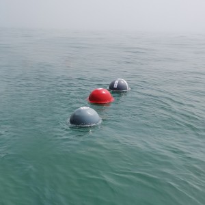
A Mooring Wave Data Buoy is a floating marine observation platform that is anchored at a fixed location using a mooring system.
Unlike drifting buoys that move with ocean currents, a moored wave buoy maintains its observation position and continuously monitors local wave conditions.
A typical mooring wave buoy system may include:
Floating buoy platform
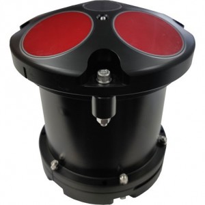
Wave measurement sensor
Data acquisition unit
Power supply system
Communication module
Mooring components
Optional meteorological and oceanographic sensors
The specific configuration depends on the monitoring objectives, deployment environment, and required observation parameters.
The buoy collects wave data over time, creating a continuous record of sea-state changes.
Why Is Wave Monitoring Important?
Ocean waves affect almost every activity conducted at sea.
Accurate wave observations are important for:
Offshore Engineering
Wave conditions directly influence:
Offshore platforms
Subsea equipment
Marine construction operations
Floating structures
Offshore renewable energy facilities
Long-term wave data help engineers understand environmental loads and design requirements.
Coastal Management
Wave energy contributes to:
Coastal erosion
Sediment transport
Shoreline changes
Nearshore circulation
Wave monitoring supports coastal research and protection planning.
Marine Safety and Navigation
Wave conditions influence:
Vessel operation
Offshore activities
Port accessibility
Marine transportation safety
Real-time wave information can support operational decisions in marine environments.
Oceanographic Research
Waves are closely connected with:
Wind conditions
Ocean circulation
Air-sea interactions
Climate variability
Continuous wave observations contribute to understanding marine processes.
How Does a Mooring Wave Data Buoy Work?
A moored wave buoy operates through a combination of floating platform technology, wave sensors, data processing, and communication systems.
Step 1: Buoy Deployment
The buoy is installed at the selected observation location using a suitable mooring system.
The mooring keeps the buoy positioned while allowing it to respond naturally to wave movement.
Step 2: Wave Motion Measurement
As waves pass through the observation area, the buoy moves with the sea surface.
The integrated wave sensor measures buoy motion or wave-related parameters according to its measurement technology.
Step 3: Data Processing
The collected signals are processed to calculate wave characteristics.
Depending on the sensor configuration, the system may provide information such as:
Significant wave height
Wave period
Wave direction
Wave frequency characteristics
Step 4: Data Storage and Transmission
The measured data can be stored locally or transmitted through a suitable communication system.
Remote data access allows users to monitor offshore conditions without frequent field visits.
Step 5: Wave Condition Analysis
The collected time-series data can be analyzed to understand:
Seasonal wave patterns
Extreme wave events
Long-term sea-state changes
Local marine conditions
What Parameters Can a Mooring Wave Data Buoy Measure?
1. Significant Wave Height
Significant wave height is one of the most commonly used parameters for describing sea conditions.
It represents the average height of the highest portion of observed waves and is widely used in:
Marine engineering
Weather forecasting
Offshore operations
Oceanographic research
2. Wave Period
Wave period describes the time interval between successive waves.
Wave period information helps researchers understand:
Wave energy characteristics
Swell conditions
Local wind-wave development
Offshore operational conditions
3. Wave Direction
Wave direction describes the direction from which waves approach.
Directional wave information is important for:
Coastal engineering
Wave modeling
Harbor studies
Offshore structure assessment
4. Wave Spectrum
Advanced wave observation systems may analyze wave frequency distribution.
Wave spectrum information provides deeper understanding of:
Wind-generated waves
Swell systems
Energy distribution across frequencies
5. Additional Environmental Parameters
Depending on the buoy configuration, additional sensors may be integrated, including:
Wind speed and direction
Atmospheric pressure
Air temperature
Water temperature
Current measurement sensors
Water-quality sensors
This allows the buoy to become part of a broader marine observation network.
Key Advantages of Mooring Wave Data Buoys
Long-Term Continuous Observation
A moored buoy can remain at a fixed observation location and collect continuous wave records over extended periods.
This makes it suitable for:
Marine research
Offshore engineering surveys
Environmental monitoring
Long-term sea-state analysis
Fixed Observation Location
Unlike drifting systems, a moored buoy provides data from a defined geographic position.
This is valuable when users need:
Site-specific wave information
Comparison between different locations
Long-term monitoring at one site
Real Marine Environment Measurement
Wave buoys directly observe actual ocean conditions rather than relying only on numerical models or remote estimation.
Measured field data can support:
Model validation
Engineering studies
Environmental assessment
Remote Data Collection Capability
When equipped with suitable communication systems, the buoy can transmit observations remotely.
This reduces the need for frequent vessel-based data collection.
Integration Capability
A wave buoy can be combined with other marine observation instruments to create a comprehensive monitoring system.
Applications of Mooring Wave Data Buoys
Offshore Engineering Projects
Wave data are fundamental for offshore structure design and operation.
Applications include:
Offshore platforms
Floating structures
Subsea engineering
Marine construction
Offshore wind projects
Observed wave conditions help engineers evaluate environmental loads and operational limitations.
Offshore Wind Monitoring
Wave conditions are important for offshore wind farm development and maintenance.
Wave data can support:
Site assessment
Construction planning
Vessel operation
Maintenance scheduling
Environmental monitoring
Coastal and Harbor Monitoring
Wave observations help understand conditions near:
Ports
Harbors
Breakwaters
Coastal infrastructure
Data can support coastal engineering and marine management.
Oceanographic Research
Wave buoys are widely used in scientific studies of:
Wave climate
Air-sea interaction
Storm events
Seasonal ocean changes
Marine Renewable Energy
Wave information is important for evaluating marine renewable energy sites.
Long-term wave records help researchers understand available energy resources and environmental conditions.
Marine Safety and Operations
Wave data can assist with:
Offshore operation planning
Vessel routing
Weather-related decision-making
Marine activity management