
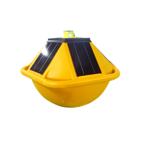
FrankStar Drifter Data Buoy – Drifting and Fixed-Mooring Ocean Observation Buoy


Our staff through experienced training. Skilled skilled knowledge, sturdy sense of provider, to satisfy the support wants of shoppers for FrankStar Drifter Data Buoy – Drifting and Fixed-Mooring Ocean Observation Buoy, “Passion, Honesty, Sound assistance, Keen cooperation and Development” are our targets. We are here anticipating mates all around the environment!
Our staff through experienced training. Skilled skilled knowledge, sturdy sense of provider, to satisfy the support wants of shoppers for drifter data buoy for ocean monitoring, drifting buoy for marine observation, drifting buoy for ocean current monitoring, drifting data buoy for oceanographic research, GNSS wave measurement drifting buoy, ocean drifter buoy with Iridium satellite communication, real-time marine observation buoy, We have been eager to cooperate with foreign companies which care much on the real quality, stable supply, strong capability and good service. We can present the most competitive price with high quality,because we’re much MORE Skilled. You are welcomed to visit our company at any time.
Key Features
Technical Specifications
Performance Specifications
|
Parameter |
Range |
Accuracy |
Resolution |
|
Wave height |
0m~30m |
<1% |
0.01m |
|
Wave direction |
0°~360° |
1° |
1° |
|
Wave period |
0s~30s |
±0.5s |
0.01s |
|
Temperature |
-5℃~+50℃ |
±0.1℃ |
0.01℃ |
|
Pressure |
700~1100hPa |
0.5hPa |
0.1hPa |
Ocean conditions are constantly changing. Waves, currents, sea surface temperature, atmospheric pressure, and other marine parameters can vary significantly across both space and time.
Traditional fixed monitoring stations provide valuable long-term observations at specific locations, but they cannot always capture how marine conditions evolve as water masses move through the ocean.
A Drifter Data Buoy provides a different approach.
The FrankStar Drifter Data Buoy is designed for mobile ocean observation, allowing the buoy to drift with ocean currents while collecting and transmitting marine environmental data. It can also support fixed-moored deployment, providing flexibility for different observation scenarios.
With integrated GNSS wave measurement technology, Iridium satellite communication, local data storage, and a large-capacity power system, the buoy is designed for long-duration marine observation and remote data transmission.
What Is a Drifter Data Buoy?
A Drifter Data Buoy, also known as an ocean drifter buoy or drifting observation buoy, is a floating marine monitoring platform designed to move with ocean or surface currents while collecting environmental data.
Unlike a conventional moored buoy, which remains anchored at a fixed location, a drifting buoy follows the movement of the surrounding water.
This provides researchers with an opportunity to observe how marine conditions change along the trajectory of a moving water mass.
Depending on the configuration, a drifter buoy can collect parameters such as:
Wave height
Wave period
Sea surface temperature
Sea-level atmospheric pressure
Ocean current velocity
Geographic position
Other environmental parameters
The collected information can be stored locally and transmitted remotely for analysis and monitoring.
How Does a Drifter Buoy Work?
The basic operating concept of a drifter buoy is relatively straightforward:
Deployment → Drifting → Environmental Observation → Positioning → Data Storage → Wireless/Satellite Transmission
After deployment, the buoy moves with the surrounding water.
At the same time, onboard sensors continuously or periodically measure selected environmental parameters.
The GNSS positioning system records the buoy’s location, allowing researchers to associate environmental measurements with specific geographic coordinates.
When satellite communication is available, observation data can be transmitted remotely for near-real-time monitoring.
This combination of mobility + environmental sensing + positioning + communication makes drifter buoys particularly useful for large-scale ocean observation.
FrankStar Drifter Data Buoy: Key Features
The FrankStar Drifter Data Buoy is designed to support both mobile and fixed marine observation applications.
Drifting and Fixed-Mooring Deployment
One of the key features of the system is its ability to support different deployment scenarios.
The buoy can be used as:
A drifting ocean observation buoy
A fixed-moored observation buoy
A mobile marine monitoring platform
A research observation system
This flexibility allows the same platform concept to be adapted to different field projects.
GNSS Wave Measurement
The Drifter Data Buoy incorporates GNSS-based wave measurement technology.
GNSS positioning data can be used to support wave observation and provide information associated with the buoy’s movement.
Depending on the system configuration, wave-related observations can include:
Wave height
Wave period
Wave motion characteristics
This provides researchers with an additional method for observing ocean surface conditions.
Iridium Satellite Communication
Marine monitoring often takes place far away from cellular communication infrastructure.
The FrankStar Drifter Data Buoy supports Iridium satellite communication, allowing observation data to be transmitted from remote marine environments.
Satellite communication can support:
Remote data transmission
Long-distance communication
Near-real-time observation
Remote monitoring
Data retrieval from offshore locations
This is particularly valuable for open-ocean deployments where conventional cellular networks are unavailable.
Large-Capacity Battery
Long-term ocean observation requires reliable power.
The Drifter Data Buoy is equipped with a large-capacity battery system designed to support extended deployment and continuous or scheduled observation.
Power consumption can be influenced by factors such as:
Sensor configuration
Sampling frequency
Data transmission frequency
Satellite communication requirements
Environmental conditions
Therefore, the actual deployment duration depends on the system configuration and operating conditions.
32 GB Local Data Storage
The buoy includes 32 GB of local data storage for onboard observation data.
Local storage provides an additional layer of data protection and allows measurement data to be retained onboard.
This is particularly useful when:
Satellite communication is temporarily unavailable
Large amounts of high-frequency data are collected
Researchers require complete historical datasets
Data transmission intervals need to be optimized
The combination of local storage + satellite communication helps provide a flexible data management strategy for remote marine observation.
What Can the Drifter Data Buoy Measure?
The FrankStar Drifter Data Buoy can support observation of several important marine parameters.
Wave Height
Wave height is a key parameter for oceanographic research, marine safety, offshore engineering, and coastal studies.
Wave observations can help researchers understand:
Sea-state conditions
Wave climate
Storm development
Offshore environmental conditions
Coastal wave processes
Wave Period
Wave period provides additional information about the characteristics of ocean waves.
Combined with wave height, wave period can support analysis of sea-state conditions and wave energy characteristics.
Sea Surface Temperature
Sea surface temperature (SST) is an important oceanographic parameter.
SST observations can support:
Oceanographic research
Climate studies
Marine ecosystem research
Air-sea interaction studies
Ocean circulation analysis
Because a drifter moves with the surrounding water, SST measurements can provide information along the buoy’s trajectory.
Sea-Level Atmospheric Pressure
Sea-level atmospheric pressure can be used to monitor atmospheric conditions over the ocean.
Pressure observations can support:
Weather and marine meteorology
Storm monitoring
Atmospheric-ocean interaction studies
Marine environmental research
Ocean Current Velocity
Ocean current velocity is essential for understanding the movement of water masses.
Current observations can support:
Ocean circulation studies
Drift trajectory analysis
Marine pollution studies
Search and rescue research
Oceanographic modeling
Coastal and offshore environmental studies
GNSS Position
GNSS positioning is especially important for a drifting buoy.
The buoy’s geographic position allows users to track its movement over time.
Combining position data with environmental observations makes it possible to analyze how marine conditions change along the buoy’s trajectory.
Products categories
-

Price Sheet for 2021 Marine Satellite Compass w...
-
Manufacture mooring and drifting standard wave ...
-

FS1600A Precise Echosounder, portable echosound...
-
Fixed Competitive Price Wave height direction p...
-

Manufacturing Companies for Accurate Digital Co...
-
2019 New Style HDPE Float Dock for Solar Floati...

