
-

Underwater Release Hook for Marine and Oceanographic Equipment
Frankstar Release Hook is independently developed and patented by SEA Research Institute. This purely mechanical release device is designed for autonomous deployment of underwater survey equipment. It has been successfully deployed for submersible marker launching aboard research vessels including Xue Long, Dong Fang Hong 2, Hai Da and Zhang Jian.Constructed with heat-treated and reinforced 316L stainless steel, the fully mechanical structure delivers outstanding reliability under extreme marine environments. It serves as essential equipment for releasing deep-sea survey markers and seabed observatory bases during oceanographic missions. -
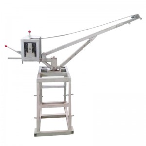
360° Rotation Mini Electric Winch for Marine Sampling
Frankstar 360 Degree Rotation Mini Electric Winch is a compact marine electric hoist developed for deploying and recovering underwater sensors, water quality sondes and sampling equipment. The lifting arm enables full 360° rotation for flexible positioning during shipboard and shore-side monitoring operations.Power-driven operation reduces manual labor during repeated sampling tasks. Constructed with anti-corrosion materials, this electric winch matches φ6mm stainless steel wire rope with a maximum length of 100m. It delivers stable load control for ocean surveys, environmental monitoring and aquaculture field missions. -
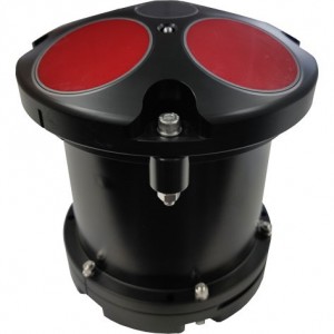
300K/600K/1200KHz Five-Beam RIV F ADCP | Acoustic Doppler Current Profiler
Frankstar Five-beam RIV F ADCP is a high-performance Acoustic Doppler Current Profiler developed for precise underwater flow field measurement. Available in 300kHz, 600kHz and 1200kHz frequency options, the five-beam ADCP delivers reliable vertical current profile data. Based on acoustic Doppler principle, it simultaneously measures current velocity, flow direction and water depth.
The five-beam configuration effectively distinguishes horizontal flow and vertical flow, greatly improving data accuracy under complex hydrological conditions. The compact, robust underwater housing adapts to coastal waters, rivers, estuaries and offshore observation. It supports long-term autonomous deployment on buoys, river monitoring stations and underwater platforms. Widely applied in hydrological survey, tidal current observation, offshore engineering, river regulation and oceanographic research.
-

In-situ Online Nutrient Analyzer for Five Nutrient Monitoring
Frankstar Nutritive Salt Analyzer is an in-house core R&D achievement. The instrument fully simulates laboratory manual analytical procedures and realizes high-quality in-situ online monitoring of five nutritive salt parameters within a single device, including nitrite nitrogen (NO₂-N), nitrate nitrogen (NO₃-N), phosphate (PO₄-P), ammonia nitrogen (NH₄-N) and silicate (SiO₃-Si). Equipped with a matched handheld terminal, it simplifies parameter configuration and delivers user-friendly operation. The analyzer supports flexible deployment on ocean buoys, survey vessels and other marine monitoring platforms.
-

Tipping Bucket Rain Gauge for Accurate Rainfall Monitoring
This instrument serves as a primary sensor for precipitation measurement. Its core component—the tipping bucket—features a 3D streamlined design that ensures smoother water discharge while offering self-cleaning capabilities and ease of maintenance. It supports both pulse and RS-485 signal outputs, allowing for direct rainfall readings without the need for secondary calculations, making it simple and convenient to use. The instrument comprises a housing, filter, rain collector, funnel, tipping bucket, terminal block, support legs, reed switch, control box, and base. The tipping bucket utilizes an integrated positioning structure for its shaft sleeve, with the bucket mounted on bearings via its shaft. As the internal components are fully assembled prior to shipment, no on-site internal assembly is required, thereby simplifying the installation process.
-

Ultrasonic Integrated Weather Station | Smart Weather Monitoring Solution
FS-YTQX-001 Compact Integrated Weather Station is widely used for environmental monitoring. It integrates optical rainfall, wind speed and wind direction, as well as temperature and humidity sensors into a single unit. The device adopts the standard MODBUS-RTU communication protocol with RS485 signal output. The communication distance can reach up to 2000 meters, enabling data transmission to customer monitoring software or PLC/SCADA systems via RS485. It also supports secondary development.
The built-in electronic compass (optional) eliminates installation orientation requirements; only horizontal installation is required. It is suitable for mobile applications such as marine vessels and vehicle transportation, with no directional constraints during installation.
This product is widely used in applications requiring measurement of ambient temperature, wind speed, and wind direction. It is safe, reliable, aesthetically designed, easy to install, and durable.
-

Drifting & Mooring Mini Wave Buoy 2.0 | Wave & Current Monitoring
Drifter is Frankstar’s intelligent wave observation buoy, equipped with high-precision sensors for waves, temperature, and pressure monitoring, and designed for both drifting and moored deployment. It provides real-time, accurate measurements of wave height, direction, period, sea surface temperature, and sea level pressure . Data is transmitted via Iridium satellite to the cloud for instant access and is also stored locally for retrieval after recovery. Compact, robust, and easy to deploy, the Drifter delivers professional, high-quality ocean data to support marine monitoring,
-

UAV-Borne Polarimetric Hyperspectral Imaging/drone based polarimetric hyperspectral camera, UAV polarimetric hyperspectral sensor system
A rotary-wing UAV remote sensing platform integrating polarimetric/hyperspectral technologies. Pixel-coregistered push-broom imaging solves traditional spatiotemporal mismatch, with airborne-ground closed-loop control for high-precision quantitative remote sensing.
-

FS 1616 Unmanned Platforms Echosounder/Altimeter | Frankstar
FS-CWYY-CW1 Tide Logger is designed and produced by Frankstar. It is small in size, light in weight, flexible in use, can obtain tide level values within a long observation period, and temperature values at the same time. The product is very suitable for pressure and temperature observation in nearshore or shallow water, can be deployed for a long time. The data output is in TXT format.
-

Radar Water Level Sensor | 80 GHz FMCW Non-Contact Measurement
FS-LDSW-001 Radar Water Level Sensor is an 80 GHz Frequency-Modulated Continuous Wave (FMCW) radar product designed for high-precision water level measurement. The maximum measuring range can reach up to 120 m, with a blind zone of less than 10 cm.
Due to its higher operating frequency and wider bandwidth, the sensor delivers improved measurement accuracy and is widely used in hydrological, water conservancy, and municipal manhole monitoring projects.
The FS-LDSW-001 adopts a non-contact measurement principle, ensuring no direct contact with the water surface. It is unaffected by water quality, sediment, or floating debris, offering excellent environmental adaptability and reliable performance in complex field conditions.
-

Gravity Corer | Seabed Sediment Sampling Equipment | Frankstar
Our integrated coring solutions cover the full range of seabed sampling needs. While our standard Gravity Corer is valued for its simplicity and reliability in obtaining columnar samples, the Piston Gravity Corer represents a definitive advancement for critical applications. Its active piston mechanism counteracts internal friction and prevents plugging, delivering longer, less disturbed cores with superior stratigraphic preservation in soft sediments.
Supported by a versatile deployment platform for heavy equipment and complemented by a selection of compact corers, our product line forms a complete system—from routine surveys to precision research—all customizable to your specific mission requirements.
-

Radar Wave & Water Level Monitoring System for Offshore Monitoring
Frankstar Radar Wave & Water Level Monitoring System is a high-precision, non-contact marine hydrological monitoring solution designed for long-term offshore and coastal wave observation. Adopting professional radar wave measurement technology, this intelligent monitoring system supports 24/7 all-weather, unattended real-time detection of critical marine parameters, including wave height, wave period, wave direction and water level.It maintains stable and accurate data output even in harsh marine environments with strong wind, heavy waves, salt fog, high humidity and extreme temperature changes. Featuring outstanding waterproof, anti-corrosion and anti-icing performance, the radar wave monitoring system is widely applicable for offshore wind farms, port and waterway monitoring, marine engineering construction, coastal environmental protection and oceanographic scientific research.Equipped with standard remote data transmission and flexible system integration functions, the device provides professional data visualization and intelligent data analysis, delivering stable, continuous and reliable hydrological data for marine safety early warning, water resource management and offshore environmental monitoring projects.


