
-

CTD Sensor for Oceanographic Monitoring | Frankstar
The Frankstar CTD Profiler (Standard Version) is a professional hydrological observation instrument designed for operation at depths of up to 6,000 meters. It supports both real-time direct-reading and self-contained operating modes, featuring high measurement accuracy, low power consumption, and low flow resistance.
The instrument accurately measures water temperature, conductivity, and pressure. It is suitable for a wide range of applications, including marine hydrological monitoring, oceanographic research, and port and waterway engineering. It can be deployed on various platforms, such as oceanographic observation stations, subsurface moorings, buoys, and multi-parameter water samplers.
-

S16 Multi Parameter Integrated Observation Data Buoy: Advanced Offshore Marine & Metocean Monitoring
The S16 Multi-Parameter Integrated Observation Data Buoy (Model: FS-MDB-S16) is an intelligent ocean observation buoy platform engineered by Frankstar. It provides all-weather, continuous, and real-time in-situ monitoring across meteorology, hydrology, water quality, ecology, and other marine parameters.
Featuring an optimized structural design and high payload compatibility, the buoy platform supports flexible sensor configurations. The top platform accommodates meteorological, communication, positioning, and navigation safety equipment, while the main hull body and lower bracket allow integration of advanced hydrological and water quality sensors. Collected data can be transmitted to the Frankstar MEINS (Marine Equipment Intelligent Networking System) platform or the user’s own system in real time via Satellite, GSM/GPRS/4G, UHF/VHF, and other communication options, enabling convenient remote access, visualization, and cloud saving.
-

S12 Multi Parameter Integrated Observation Data Buoy: Real-Time Marine & Metocean Monitoring
The S12 Multi-Parameter Integrated Observation Data Buoy (Model: FS-MDB-S12) is an intelligent, high-performance ocean observation buoy platform engineered by Frankstar. It enables all-weather, continuous, real-time in-situ monitoring across meteorology, hydrology, water quality, ecology, and other marine parameters.
Featuring excellent industrial design and high payload compatibility, the buoy platform accommodates flexible sensor configurations. The top platform houses meteorological, communication, positioning, and navigation safety equipment, while the structural body and lower frame allow the integration of advanced hydrological and water quality sensors. Collected data can be transmitted to the Frankstar MEINS (Marine Equipment Intelligent Networking System) platform or user-specific management platforms in real time via Satellite, GSM/GPRS/4G, UHF/VHF, and other communication options, enabling remote access, visualization, and cloud storage.
-

Mooring Wave Data Buoy for Ocean Wave Monitoring and Marine Observation
The Mooring Wave Data Buoy (Standard) is a versatile, high-precision oceanographic monitoring buoy developed by Frankstar to deliver continuous, long-term sea observation. Engineered with advanced multi-channel acquisition technology, it provides accurate measurements of wave dynamics, physical ocean parameters, and marine environmental elements. Operating effectively in both free-drifting ocean profiling and fixed-station mooring modes, the buoy transmits real-time telemetry back to land stations or cloud platforms via satellite, cellular, or radio communication networks.
-
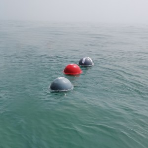
Lagrange Drifting Buoy | Ocean Surface Current, Temperature and Salinity Observation System
Drifting buoy can follow different layers of deep current drift. Location via GPS or Beidou, measure ocean currents by using Lagrange’s principle, and observe the Ocean surface temperature. Surface drift buoy supports remote deploy through Iridium,to get the location and data transmission frequency.
-

Radar Water Level & Velocity Station for River, Canal, and Hydrological Monitoring
Frankstar Radar Level Velocity Station adopts non-contact radar measurement technology to achieve high-precision, all-weather and automatic water level data collection for rivers, channels and other water bodies. It effectively overcomes the drawbacks of traditional contact sensors, such as siltation, icing, floating debris impact and biological fouling, ensuring long-term reliable data.
Integrated with a positioning system, 4G/5G communication and a high-efficiency solar power supply system, the Station enables long-term unattended operation in remote field environments without mains power or network coverage, greatly reducing operation and maintenance costs. Collected data is transmitted in real time to the monitoring center or cloud platform, providing a scientific basis for flood control, disaster mitigation, water resource management and ecological protection, while significantly improving emergency response efficiency and the safety of water conservancy facilities.
-
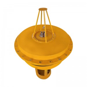
Wind Buoy for Offshore Wind and Marine Meteorological Monitoring
Wind buoy is a small measuring system, which can observe the wind speed, wind direction, temperature and pressure with the current or in fixed point. The inner floating ball contains the components of the whole buoy, including weather station instruments, communication systems, power supply units, GPS positioning systems, and data acquisition systems.The collected data will be sent back to the data server through the communication system, and customers can observe the data at any time.
-

Self-Recording Pressure and Temperature Observation Tide Logger | Tide Monitoring
FS-CWYY-CW1 Tide Logger is designed and produced by Frankstar. It is small in size, light in weight, flexible in use, can obtain tide level values within a long observation period, and temperature values at the same time. The product is very suitable for pressure and temperature observation in nearshore or shallow water, can be deployed for a long time. The data output is in TXT format.
-

CTD Hydrological Sensor | Conductivity, Temperature and Depth Profiler
Frankstar series CTD (Standard Version) is a professional hydrographic observation instrument. It adopts an integrated direct-reading and self-contained operating mode, featuring high accuracy, low power consumption, and low flow resistance. It can accurately measure temperature, conductivity, and depth in water bodies.
-
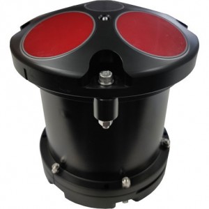
Five-beam RIV-F ADCP Acoustic Doppler Current Profiler | Flow Velocity & Current Measurement
Frankstar Five-beam RIV F ADCP is a high-performance Acoustic Doppler Current Profiler developed for precise underwater flow field measurement. Available in 300kHz, 600kHz and 1200kHz frequency options, the five-beam ADCP delivers reliable vertical current profile data. Based on acoustic Doppler principle, it simultaneously measures current velocity, flow direction and water depth.
The five-beam configuration effectively distinguishes horizontal flow and vertical flow, greatly improving data accuracy under complex hydrological conditions. The compact, robust underwater housing adapts to coastal waters, rivers, estuaries and offshore observation. It supports long-term autonomous deployment on buoys, river monitoring stations and underwater platforms. Widely applied in hydrological survey, tidal current observation, offshore engineering, river regulation and oceanographic research.
-
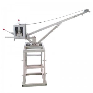
360 Degree Rotation Mini Electric Winch | Marine Equipment Deployment System
Frankstar 360 Degree Rotation Mini Electric Winch is a compact marine electric hoist developed for deploying and recovering underwater sensors, water quality sondes and sampling equipment. The lifting arm enables full 360° rotation for flexible positioning during shipboard and shore-side monitoring operations.Power-driven operation reduces manual labor during repeated sampling tasks. Constructed with anti-corrosion materials, this electric winch matches φ6mm stainless steel wire rope with a maximum length of 100m. It delivers stable load control for ocean surveys, environmental monitoring and aquaculture field missions. -

Drifting & Mooring Mini Wave Elf 2.0 Data Buoy | Wave & Surface Current Monitoring
Mini Wave Elf 2.0 is a new generation of small intelligent multi-parameter ocean observation data buoy developed by Frankstar Technology. It can be equipped with advanced wave, temperature, salinity, noise and air pressure sensors. Through anchorage or drifting, it can easily obtain stable and reliable sea surface pressure, surface water temperature, salinity, wave height, wave direction, wave period and other wave element data, and realize continuous real-time observation of various ocean elements.
The data can be sent back to the cloud platform in real time through Iridium, HF and other methods, and users can easily access, query and download the data. It can also be stored in the SD card of the buoy. Users can take it back at any time.
Mini Wave buoy 2.0 have been widely used in marine scientific research, marine environmental monitoring, marine energy development, marine forecasting, marine engineering and other fields.


