
-
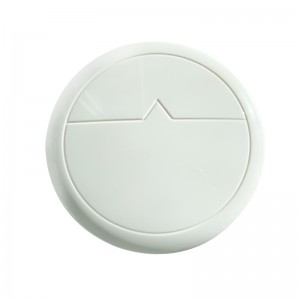
Frankstar Wave Sensor 2.0 to Monitor Ocean Wave Direction Sea Wave Period Marine Wave Height Wave Spectrum
Introduction
Frankstar Wave Sensor 2.0 is a solution for real-time ocean wave monitoring. Based on a nine-axis acceleration principle and advanced proprietary algorithms, it accurately measures wave height, wave period, wave direction and wave spectrum. Featuring a lightweight, heat-resistant design and ultra-low-power embedded processing, the sensor supports real-time data transmission via RS232 interface and integrates seamlessly with ocean buoys, drifting buoys, and unmanned platforms. Available in Basic, Standard, and Professional versions, it is designed to meet diverse wave observation needs.
-

CTD Hydrological Sensor – Conductivity, Temperature and Depth Profiler for Oceanographic and Water Quality Monitoring
Frankstar series CTD (Standard Version) is a professional hydrographic observation instrument. It adopts an integrated direct-reading and self-contained operating mode, featuring high accuracy, low power consumption, and low flow resistance. It can accurately measure temperature, conductivity, and depth in water bodies.
-

Frankstar RNSS/ GNSS Wave Sensor
Frankstar RNSS Wave Sensor is a next-generation solution for real-time ocean wave monitoring. Leveraging low-power embedded processing and RNSS positioning technology, it adopts proprietary algorithms to accurately measure wave height, wave period and wave direction. Equipped with lightweight marine-grade housing and standard RS232 interface, the sensor enables seamless integration with ocean buoys, unmanned surface vessels and various offshore platforms. Built-in positioning and timing modules make this RNSS Wave Sensor perfectly suited for marine environmental monitoring, navigation safety, offshore engineering and oceanographic scientific research.
-

Mooring Wave Data Buoy (Standard)/oceanographic, metocean, meteorological, offshore, coastal, telemetry, data logger, real‑time, deployment, AIS, GPS, buoy system, marine monitoring
The Mooring Wave Data Buoy (Standard) is a versatile, high-precision oceanographic monitoring buoy developed by Frankstar to deliver continuous, long-term sea observation. Engineered with advanced multi-channel acquisition technology, it provides accurate measurements of wave dynamics, physical ocean parameters, and marine environmental elements. Operating effectively in both free-drifting ocean profiling and fixed-station mooring modes, the buoy transmits real-time telemetry back to land stations or cloud platforms via satellite, cellular, or radio communication networks.
-
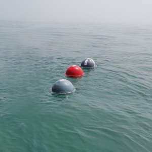
Disposable Lagrange Drifting Buoy (SVP type) to Observe Ocean/ Sea Surface Current Temperature Salinity Data with GPS Location
Drifting buoy can follow different layers of deep current drift. Location via GPS or Beidou, measure ocean currents by using Lagrange’s principle, and observe the Ocean surface temperature. Surface drift buoy supports remote deploy through Iridium,to get the location and data transmission frequency.
-

Oil Polution Tracker/ Oil Spill Detection Monitoring Buoy
The Oil Spill Detection Monitoring Buoy is an advanced marine environmental observation buoy developed by Frankstar to detect, monitor, and track offshore hydrocarbon leaks and oil spill incidents in real time. Equipped with high-precision optical and chemical hydrocarbon sensors, the buoy provides continuous, early-warning surveillance across critical maritime zones, ports, and offshore energy infrastructure. Operating in both free-drifting and fixed mooring modes, it captures high-fidelity environmental data and transmits real-time alerts and telemetry to shore stations or cloud monitoring platforms via satellite, cellular, or radio communication networks.
-
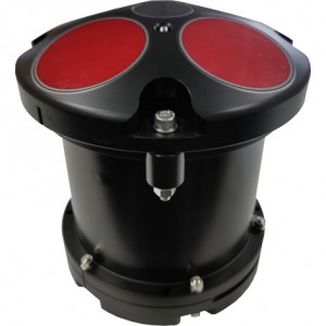
Frankstar Five-beam RIV F ADCP Acoustic Doppler Current Profiler/300K/ 600K/ 1200KHZ
Frankstar Five-beam RIV F ADCP is a high-performance Acoustic Doppler Current Profiler developed for precise underwater flow field measurement. Available in 300kHz, 600kHz and 1200kHz frequency options, the five-beam ADCP delivers reliable vertical current profile data. Based on acoustic Doppler principle, it simultaneously measures current velocity, flow direction and water depth.
The five-beam configuration effectively distinguishes horizontal flow and vertical flow, greatly improving data accuracy under complex hydrological conditions. The compact, robust underwater housing adapts to coastal waters, rivers, estuaries and offshore observation. It supports long-term autonomous deployment on buoys, river monitoring stations and underwater platforms. Widely applied in hydrological survey, tidal current observation, offshore engineering, river regulation and oceanographic research.
-

Radar Wave & Water Level Monitoring System
Frankstar Radar Wave & Water Level Monitoring System is a high-precision, non-contact marine hydrological monitoring solution designed for long-term offshore and coastal wave observation. Adopting professional radar wave measurement technology, this intelligent monitoring system supports 24/7 all-weather, unattended real-time detection of critical marine parameters, including wave height, wave period, wave direction and water level.It maintains stable and accurate data output even in harsh marine environments with strong wind, heavy waves, salt fog, high humidity and extreme temperature changes. Featuring outstanding waterproof, anti-corrosion and anti-icing performance, the radar wave monitoring system is widely applicable for offshore wind farms, port and waterway monitoring, marine engineering construction, coastal environmental protection and oceanographic scientific research.Equipped with standard remote data transmission and flexible system integration functions, the device provides professional data visualization and intelligent data analysis, delivering stable, continuous and reliable hydrological data for marine safety early warning, water resource management and offshore environmental monitoring projects. -

Mobile Shipborne Water Quality Monitoring System
Frankstar Shipborne Water Quality Monitoring System is a fully integrated autonomous onboard system designed for continuous marine water quality observation. It integrates multi-parameter water quality sensors and high-sensitivity nutrient analyzers adopting mature wet chemistry methodology, capable of outputting laboratory-grade data under real marine environments.Supported by GNSS/Beidou positioning and vessel speed feedback, the intelligent control module realizes adaptive sampling while sailing. Equipped with fully automatic mode and operator-assisted mode, along with auto-calibration and automatic maintenance functions, the system maintains long-term stable and reliable performance and greatly reduces manual workload.Developed for unattended field deployment, the system supports continuous data collection, storage and remote transmission. It can supply high-quality measured datasets for oceanographic studies, marine environmental surveillance and smart ocean observation networks. -

Water Quality Sonde Series
Frankstar Water Quality Sonde Series leverages advanced fluorescence lifetime dissolved oxygen sensing technology to deliver stable, high-precision, real-time water quality data. Designed for diverse aquatic monitoring environments, our modular multi-parameter water quality sonde supports flexible configurations from compact 2-sensor setups to fully integrated multi-parameter systems, providing accurate and reliable data for professional water quality analysis and water resource management.
-

FS 1621 Multibeam Echosounder
The FS162I is a brand new high resolution multibeamechosounder product series.The ideally selected210kHz frequency provides excellent data quality andease of use over depths from Im to 500m.Equi-Distant
and Equi-Angle modes can be selected from operationsoftware.With comparable performance to that of simi-lar advanced MBEs in the world,the FS162I is perfectlyused in channel dredging,geological survey,coastal andestuary survey,shipwreck salvage and other applications. -

FS 1616 Unmanned Platforms Echosounder/Altimeter
The FS1616 is a miniature echosounder specally designedfor unmanned vehides.Its 446kHz operation frequency canbe used for survey in 0.3m ultra-shallow waters.Besides,it’s also convenient to deploy on unmanned platforms suchas underwater ROV,AUV,glider,fixed platform,etc.,tomeasure the height of the platform to the bottom of thewater to protect flying equipment.
The structure is more compact and it’s easy to deploy.The FS1616 supports DC power supply,wide voltage andlow power consumption.The new digital signal processingtechnology and optimized automatic gain make the surveymore accurate and reliable.The frequency and depth ratedcan be customized according to customer requirements.


